| KM |
DESCRIPTION |
| START |
In Main Road to Fish Hoek, at the southern side of the Dido Valley robot intersection next to the robots, facing north. |
|
Runners run on the right hand side of the road whilst running out along Main road until they reach Hillside road where they |
|
cross over to the left hand side of the road and continue on that side until the Glencairn Expressway intersection |
| 1 |
In Main Road to Fish Hoek, opposite Dixie’s on LHS |
| 2 |
In Main Road to Fish Hoek, 100m before lookout point on RHS after Glencairn, and opposite large granite rock on LHS |
| 3 |
In Main Road to Fish Hoek, 35m after yellow fire hydrant on LHS. Cross over to left at Hillside road |
| 4 |
In Main Road to Fish Hoek, at Ballycline steps on lhs |
| 5 |
Kommetjie Road, Fish Hoek, 5m before pedestrian crossing at False Bay College, just past bus stop on RHS |
| 6 |
Kommetjie Road, Fish Hoek, 3m after robots at intersection with 17th Ave |
| 7 |
Kommetjie Road, Fish Hoek, 8m after chevron sign on LHS just after 20th Ave ( road to FHAC) |
| 8 |
Kommetjie Road, Fish Hoek, 100m before robots at Glencairn Expressway intersection |
|
Runners turn left at these robots and cross over immediately to the right hand side of the road as they run over Black Hill |
| 9 |
Black Hill, 15m after start of white slabs on RHS before arm curve barrier and 30m after 90km/hr sign on LHS |
| 10 |
Black Hill, 100m before roadway on RHS to gate into TMNP area, just before top of Black Hill |
| 11 |
Black Hill, 100m after half marathon 13km mark, opposite embankment on LHS, after crest of hill |
| 12 |
Black Hill, half way down Black Hill, 30m before speed limit enforcement sign on LHS and 30m after M6N sign on RHS |
| 13 |
Black Hill, near bottom of Black Hill, 20m after 90km/hr sign on RHS before Total garage |
|
Runners then turn right onto Main Road and continue running on the right hand side of the road until they reach Red Hill |
| 14 |
Main Road to Simonstown, at ‘No stopping” sign opposite entrance to Glencairn Station on LHS |
| 15 |
Main Road to Simonstown, 8m before third entrance to old Marine Oil refinery on RHS |
|
Runners then run over Red hill staying on the left hand side of the road. |
| 16 |
Red Hill Road, 20m after Main Road intersection, just after entrance to bus depot on RHS |
| 17 |
Red Hill Road, amongst Blue gum trees, 12m before hairpin bend sign on RHS |
| 18 |
Red Hill Road, 70m after hairpin bend sign on RHS |
| 19 |
Red Hill Road, 150m before hairpin bend sign before view site on LHS |
| 20 |
Red Hill Road, 75m after Brookland Water scheme turn off on RHS |
| 21 |
Red Hill Road, at top of Red hill |
| 21,1 |
Red Hill Road, just after top of Red Hill, at entrance to Winford farm on RHS |
| 22 |
Red Hill Road, half way down red Hill 30m before parking area for bus stop on RHS |
| 23 |
Red Hill Road, on way down Red Hill 15m before last set of shacks on RHS, opposite large burnt our pine tree on LHS |
|
Runners bear left at the bottom of Red Hill and then cross over to the right hand side of the road and continue on that |
|
side of the road until the finish in Simonstown |
| 24 |
Road to Cape Point, (M62) 80m before Cape Point Vineyards sign on LHS |
| 25 |
Road to Cape Point, (M62) 100m before entrance to Cape point nursery on LHS |
| 26 |
Road to Cape Point, (M62) 5m after fire hydrant and 20m before transformer on pole on RHS |
| 27 |
Road to Cape Point, (M62) 1m before white culverts |
| 28 |
Road to Cape Point, (M62) 50m after white bridge |
| 29 |
Road to Cape Point, (M62) 80m before culverts on either side of the road, in row of pine trees |
| 30 |
Road to Cape Point,(M62) 80m before white culvert on RHS on hill up to Cape Point entrance |
| 31 |
Road to Cape Point, (M62), 6m after horses sign on RHS, 100m after Cape Point Ostrich Farm entrance on LHS |
| 32 |
Road to Simonstown, (M62), just after descent to SmitWinkels Bay, 80m after big pine tree on LHS |
| 33 |
Road to Simonstown, (M62), 5m before white bridge on LHS, on RH bend |
| 34 |
Road to Simonstown, (M62), 100m before Millar’s Point on RHS, and opposite steep embankment on RHS, 2m after manhole |
| 35 |
Road to Simonstown, (M62), on LH bend opposite rocky cliffs on LHS and 100m before parking area on RHS |
| 36 |
Road to Simonstown, (M62), 15m after two big white painted rocks on RHS, and 20m after driveway on LHS |
| 37 |
Road to Simonstown, (M62), 80m before entrance to Black Marlin restaurant on RHS |
| 38 |
Road to Simonstown, (M62), at driveway next to tall pine tree on RHS |
| 39 |
Road to Simonstown, (M62), half way along metal fence on RHS, 35m before LH intersection sign on LHS |
| 40 |
Road to Simonstown, (M62), 3m before wooden fence on RHS just before start of Cape Times Fresh Air Fund complex |
|
on LHS |
| 41 |
Road to Simonstown, (M62), next to Dunearn on RHS, just before school on LHS |
|
Runners the turn right into Martello Drive and then proceed onto the field at the north eastern corner of the field |
| 42 |
Martello Drive, half way down road to naval sports fields |
| 42,195 |
Naval Sports ground fields, Simonstown, on halfway line of soccer field facing south |
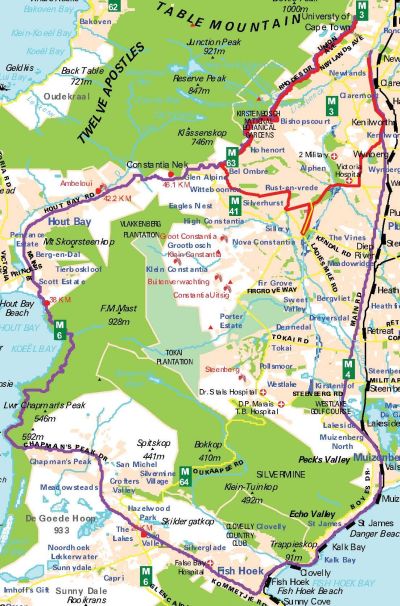
 With the Two Oceans Marathon Entry date approaching soon, we want to give you an overview for the highlight of the 2011 Marathon season in Africa. We already wrote about the Two Oceans Marathon Entry requirements and limitations in a previous post.


